Who paid the ferryman

Today we left St Austell and headed towards Menheniot.

St Austell is named after the 6th century Cornish saint, St Austoll, a disciple of St Mewan. In a Vatican manuscript there is a 10th-century list of Cornish parish saints. This includes Austoll, which means that the church and village existed at that time, shortly after 900.

The first hour or so out of St Austell was through urban areas, so a little bit hilly and pavements, but on leaving the town we hit our first big hill of the day – pretty steep and over 1km of constant walking upwards! We eventually made it to Fowey (via more hills and steepish descents) to try and find some lunch before taking the chainlink ferry across to Bodinnick. Without a long walk (we didnt need the extra steps today) the only option was a small catering van. Excellent sandwiches though and then a nice short crossing of the River Fowey.

Obviously a long hill back up from the ferry and then a long walk through farmlands and quiet country lanes. We passed the Cornish Gouda Company (made famous by Rick Stein’s cornwall series) and had a brief stop in Penylt for an ice cream before heading back into the woods and fields.

Onwards and upwards (or so it felt), even taking a wet/muddy path for a while, we eventually made our way to Menhiot and our accommodation for the evening. On the back of two tough days this was brutal in terms of hill climbing – thankfully for the afternoon the sun hid behind clouds to make it slightly more bearable.

Map of our route today and the climbs/descents

Over the hills and far away …..

Today we were joined by Lauren for our journey from Camborne to St Austell.

After an eventful night outside the hotel (domestic disputes, fights, ambulances, police, etc. – none of which were anything to do with us!) it was breakfast as soon as they started serving and then off we set. We ambled through Camborne and the outskirts of Redruth before hitting the quieter roads.

Redruth’s name derives from its older Cornish name, Rhyd-ruth. It means Red Ford (literally ford red). During a boom for copper ore in the 18th century, Redruth (surrounded by copper ore deposits), quickly became one of the largest and richest mining areas in Britain and the town’s population grew markedly, although most miners’ families remained poor.

We then passed through multiple small towns such as St Day, Chacewater and Threemilestone before getting to St Emre (just over half way for the day). We looked for some lunch in St Emre but asking for a sandwich was way too difficult for the staff to understand in the bar so we moved on and agreed our own snacks were the way forward!

Carrying on – btw it was very hot out of the shade, so much so that the caps and hats made an appearance – the hills were also relentless as we made our way into St Austell via an ice cream stop. We also had a good view of the “Cornish Alps” which are really piles of spoil from the local china clay mines.

Safe to say we were pretty shattered at the end – 48km, 900m of climb and heat! Kudos to Lauren who achieved a personal best for distance walked today!

Tomorrow sees us head to Menheniot as we edge towards Devon in a couple of days.

Todays route and a graphic the climbs/descents of the day.

Felt so good

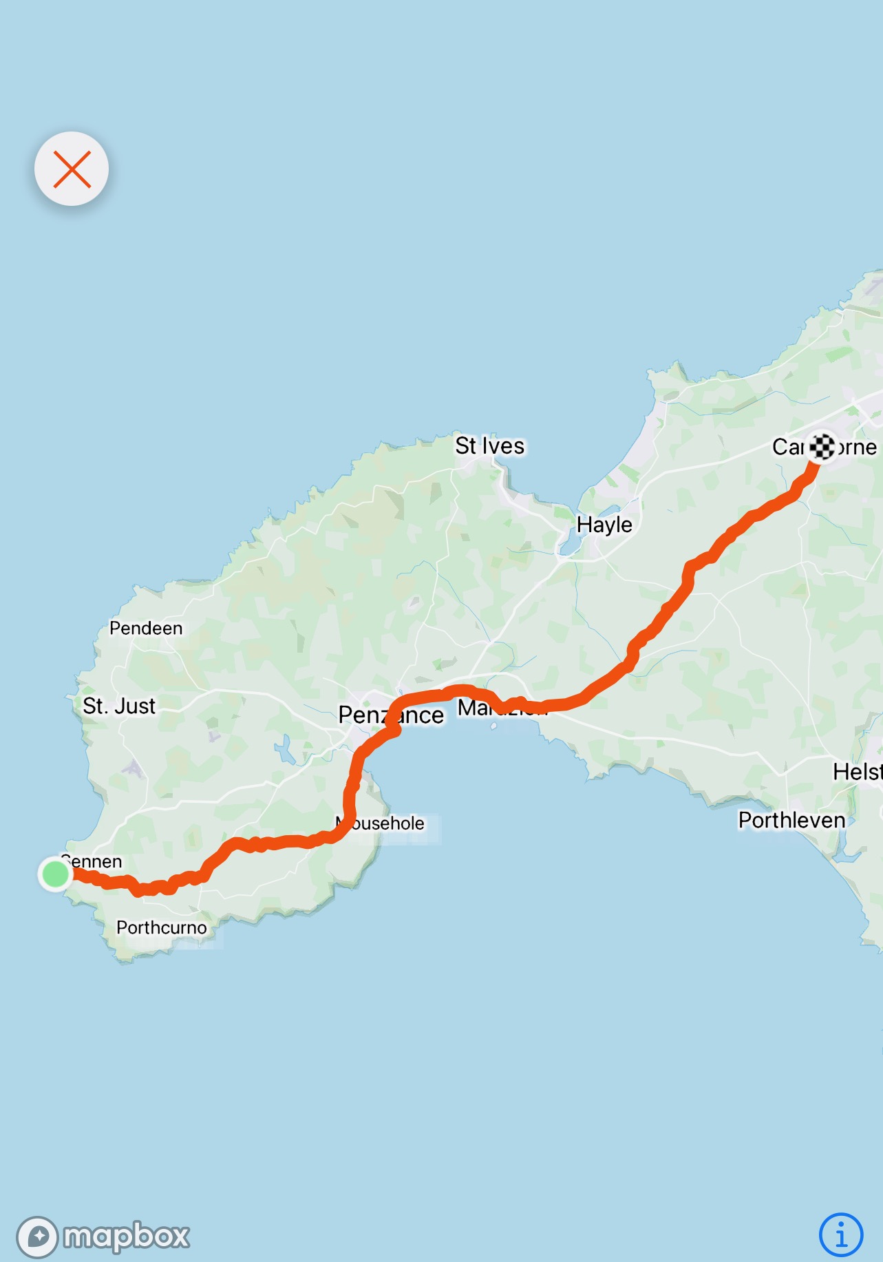
Today we started our walk back from Land’s End to John O’Groats. Today’s destination would be Camborne, some 41 km away and it felt really good to be back on the road.

The weather was lovely as we set out, sunny with a bit of a breeze as we made our way from Land’s End to Penzance. Such a contrast to this route last year which was torrential rain and wind. This is the church at St Buryan last year and today.

A very pleasant walk then ensued, along the coast path from Newlyn through to Marazion with some great views of St Michaels Mount and the causeway across to it as the the was retreating.

We then walked inland and headed northeast towards Camborne. Not a whole lot to report on as the road (mercifully quiet) meandered through farmland and nicely tree lined lanes (kept the sun off) and of course it was hilly

We finally arrived at our hotel in Camborne where a Cornish Cream Tea was our reward for our efforts. Camborne is named after kammbronn in Cornish which means “crooked hill”. It was one of the world richest tin mining areas n the late 18th and early 19th centuries.

Todays route and a graphic the climbs/descents of the day.

Tomorrow we head back to the south coast of Cornwall and St Austell.

Please feel free to click on the image on the top right hand side of the page to donate to these great causes.

We’re at it again!

When I told my children that we are going to walk from Land’s End to John O’Groats, my youngest (Niamh) posted the following on instagram. So apt I thought I’d use it as the title of my first blog entry for this walk

(c) Niamh Fanning

We are now settled into the Land’s End Hotel for a last relax before the big day tomorrow. It seems crazy that only one year ago Paul and I were at Land’s End having finished our walk. We had absolutely no intention of ever doing it again – but here we are. Everything packed – main bag for its’ car journey to Camborne tomorrow (thank you Helen) and backpack also ready for the walk.

There are some stunning views from the hotel:

Breakfast at 8am tomorrow and then we set off the 41km / 26 miles to Camborne, hoping the weather stays nice but not too hot.

Of course this walk is all about raising money for two very deserving Hospices – click on the image to the right of the page to go to the sponsorship page please.

We enjoyed walking from John O’Groats to Land’s End so much that we are walking the reverse route this year !

On 28th August, we (Myself, Paul and Mike) will start our walk from Land’s End to John O’Groats.

This is the reverse of our walk completed in 2020 in support of Haven House Children’s Hospice.

Mike Palfreman has moved from the CEO of Haven House to the CEO of Jersey Hospice Care and as both Hospices celebrate the shared aims of all hospices across the UK we will be raising funds for both Hospices.

“To help bring dignity and choice to those living with dying and to help all, of whatever age, live life to the full.”

All funds raised will be split 50/50 between Jersey Hospice Care and Haven House Children’s Hospice and will be even more critical at this time in enabling both hospices to withstand the impact of the ongoing pandemic.

You can read about the services of both amazing charities by clicking on the Hospice logos at the top of the page.

As last year, this blog will be updated daily (where wifi allows) and we will hopefully joined by 50+ walkers on different legs of our journey.

Please support us, and all the walkers who will join us, in this immense challenge, and through them Jersey Hospice Care and Haven House, by sponsoring for as much as you can afford.

A very big thank you from all of us in advance.

The adventure in numbers

Having finished our epic adventure, here are some statistics:

– We spent a total of 275 hours walking at an average 9.5 hours per day

– We walked approx. 1400 km / 874miles at average of 48km / 30 miles (more than a marathon) per day

– We climbed a total of 16800m (same for descent) – Everest is 8,848m

– We burnt over 105,000 active calories (as opposed to “just sitting around” calories) at an average of 3,600 per day

– I took 1,725,000 steps (Paul probably took more)

– We stayed at 29 different hotels (Paul was 30)

– 42 people joined us to walk some of the legs or provide driving support

– £68,000 raised so far

If you were waiting to donate for us to finish, then now is the time at the link at the top of this page

The Glory Leg

Today would be the last leg of our epic adventure as we walk from Penzance to Land’s End. We are joined today by Gareth, Andy and Chris for the final (glory) leg – Mike is walking instead of driving as well.

The weather was truly awful as we left the hotel in Penzance – heavy rain and strong winds in our faces. Penzance is the base of the pirates in Gilbert and Sullivan’s Comic opera, The Pirates of Penzance. At the time the libretto was written, 1879, Penzance had become popular as a peaceful resort town so the idea of it being overrun by pirates was amusing to contemporaries. Penzance—Pennsans; “holy headland” in the Cornish Language —refers to the location of a chapel nowadays called St Anthony’s that is said to have stood over a thousand years ago on the headland to the west of what became Penzance Harbour.

This would be a short walk today (only 18kms) but as usual started with a steep hill out of Penzance in the wind and the rain. A nice church in Saint Buryan and an old gun emplacement in St Levan were the only things of note. Fortunately, within about 5km of Land’s End the rain and wind stopped – even offering glimpses of blue sky as we finally reached the A30, a view of the sea and the Land’s End marker.

Sue had organised some of the visitors to applaud us as we crossed the “finishing line” which was a very nice touch. The Land’s End signpost is privately owned so each photograph costs £11 (unlike John O’Groats where it is free to all). The long queue for photos very generously let us jump the queue – while we wait for the emailed official photo, here are the unofficial iPhone versions.

This has been an epic, once in a lifetime adventure that would not have been possible without the support of Helen & Sue; Mike, Graeme, Mark, Greg, Darren & Louis who drove our bags around the country and generally looked after us and of course the 40 friends and colleagues who joined us for one of more legs.

Tomorrow’s final blog entry for this walk will be some statistics that cover the last 33 days.

Thank you to The Media People for sponsoring today’s leg.

Last full day of walking

Today we would leave Probus and head for Penzance on our last full day of walking.

We left Probus early and headed towards Truro on our way to Penzance. Probus has the tallest church tower in Cornwall at 129 feet (39 m) high and is richly decorated with carvings.The town’s name originates from the church’s dedication to Saint Probus.

A lot of mist in the fields as we set out, but with the sun rising it quickly burnt off the mist.

We walked through Truro taking the opportunity for a coffee and a last photo outside a HSBC branch. Truro is Cornwall’s county town and it’s only city. Truro grew as a centre of trade from its port and then as a stannary town for the tin-mining industry. It became entitled to be called a city in 1876, with the founding of the Diocese of Truro, and thereby became mainland Britain’s southernmost city.

In a welcome deviation from the road we joined the Mines Trail and walked through the Wheal Maid Valley – this was a copper ore mine and produced over one million tonnes during the 18th and 18th centuries from mines that went over 350m deep.

We then took the Great Flat Lode Trail, around Carn Brea, which was covered with old engine houses and ventilation towers. This was so named because the tin-bearing rock was at an unusually shallow gradient of about 10 degrees to the horizontal – in other parts of Cornwall mineral bearing lodes lie at between 60 and 90 degrees to the horizontal – its small gradient allowed for optimal location of the mines.

After a long walk down a tree lined B-road with limited views, we got our first sight of St Michael’s Mount in Penzance Bay. Historically, St Michael’s Mount was a Cornish counterpart of Mont-Saint-Michel in Normandy (with which it shares the same tidal island characteristics and the same conical shape, though it is much smaller, at 57 acres, than Mont St Michel which covers 247 acres), when it was given to the  Benedictine religious order of Mont Saint-Michel by Edward the Confessor in the 11th century.

Blessed by good weather, today felt a very long day – maybe being the last full walking day added to that feeling.

Tomorrow looks like heavy rain all morning for our walk to Land’s End and the closure of this (very) long and enjoyable adventure.

Thanks to Philip Leigh Pop Up Properties for kindly sponsoring todays leg

We entered Probus via the back route (quote M. Palfreman)

Today we would leave Menheniot and head cross country to Probus. Mike is walking & driving so this is the first day for a very long while that we have had no company for the whole day.

We left Menheniot early this morning in the mizzle and headed via back roads to Probus. Menheniot (pronounced Men-en-yut) lies in a former mining area and is surrounded by disused shafts and engine houses. Lead seams were discovered in the 1840s and Menheniot became the centre of a mining boom which lasted until the 1870s.

As we walked up incessant hills the view alternated between mist and not quite so much mist, once allowing us a view of Looe in the distance.

As we reached Pelynt we could see a Spar and an opportunity for an ice-cream (we have missed these for the last few days). The name Pelynt derives from the Cornish pluw (parish) and the name of Saint Non, the mother of St David. The manor of Pelynt is mentioned in the Domesday Book (1086) when it was valued much higher than Looe.

As we closed in on the Fowey-Bodinnick ferry we entered into “Du Maurier Country”. Dame Daphne du Maurier, Lady Browning, was an English author and playwight who spent much of her life in Cornwall, where most of her works are set.

We took the ferry across the River Fowey from Bodinnick – some very nice houses along both sides of the river.

Our route from the River Fowey took us through Par (where we met Mike for our lunch) and up towards Carlyon Bay where we had the option of following the South West Coast Path for a bit – it was lovely to walk beside the sea for a while and a welcome change from continually pounding tarmac. The path took us alongside the Carlyon Bay Golf Course – looked beautiful but challenging to play.

We then walked past St Austell and to our B&B in Probus. As ever at the end of a long day’s walk, focus turns to completing the day rather than considering photographic options, especially with busy roads to navigate.

Tomorrow is our final “full” day of walking (a 50+ km day) as we head to Penzance.

Thanks to Orbian for kindly sponsoring today’s leg from Menheniot to Probus